Posts Tagged ‘Maps

23
May
12

Tablet Wars: The OS Battle

Ever since the iPad burst onto the scene, tablets have been the darlings of consumers and educators alike, with hundreds of millions of units sold. But is the US market indicative of the Worldwide trend in mobile platform adoption?

This past week on the NPR/KQED MindShift education blog, Frank Catalano examines the trends in the global market and finds that while Apple has a majority of the market share in tablet adoption by both consumers and educators in the US, it is Google’s Android that is leading the way with multiple sub-$150 devices being created in several countries and large scale adoption on a national level. Read Frank’s post here: “Which device will win the tablet battle?

Image

The question for publishers and content developers then becomes how to create content and curriculum as platform-agnostic as possible in order to capitalize on the adoption of as many of these devices as possible worldwide. At the moment, there are no easy answers, especially when publishers have to reach schools that are on the front lines in adopting the newest technology as well as those that lag behind, having to make do with years-old hardware and software.

At Maps.com, we are creating content and applications both specific to iOS and Android operating systems as well as cross-platform applications – primarily with HTML5. For instance, in our Maps101 Web service, we have long had a collection of hundreds of outline maps and a Flash-based MapKit drawing tool for users to create and modify their own maps. This month we released a new tool called MapSketch that adds to all of our maps an HTML5-based drawing tool that is cross-platform compatible. MapSketch will also be made available to add the same drawing tools to third party sites and applications such as Interactive White Board Activities. Contact us to find out how.

20
Apr
12

GPS – For the love of the rain forest.

People indigenous to some of the world’s most precious natural environments are helping to preserve their way of life using GPS mapping.

Communities native to the world’s second biggest rainforests in the Congo Basin, for example, rely on the ecosystem for 80-90% of their resources, through activities such as hunting and fishing that they have practised for years.

GPS_Training_in_DRC

GPS training in the DRC: Rainforest Foundation.

Because they are semi-nomadic, meaning that they move around the rainforest rather than living in a single, fixed location, the extent to which they live and work there is often disputed. The rainforests are under constant threat from industries such as logging and farming (both legal and illegal), so already these people are used to seeing their world shrink around them. But even conservation itself can, ironically threaten their way of life, as frequently protections not only prevent the destruction of the forest but also their right to continue their own activities there.

Tribes are also enabled, using their GPS devices, to hold companies who have been granted specific rights to be held accountable when they exploit or violate restrictions that have been set upon their operations. For example more than 6000 Bantu and 1500 Pygmies are now involved in policing logging activity in the Bandundu and Equateur provinces of the Democratic Republic of Congo through participatory mapping.

Organizations such as Rainforest Foundation UK have been training community members as ‘Master Mappers’ to create maps by initially sketching their homeland out and then using GPS devices to accurately locate the places on the map.

The aim is to create a territory map that can be presented to the Congolese Government when they meet on May 8th to determine the future of the rain forest – with regard to parceling of the forest for industrial purposes. The government has already made 11 concessions to logging companies from several European nations.

The maps will be offered as hard proof that these communities exist and live throughout the rainforest, and offer their representatives a chance to play a part in negotiations about their homeland.

As reported on CNN, a similar project has existed for more than 10 years in the Cameroon, where tribes in the Boumba Bek collected honey, mangoes and medicinal plants prior to it receiving National Park status under the jurisdiction of the World Wildlife Fund.

The Baka people were able to provide similar GPS based evidence and restore their right to operate within the region.

GPS offers an opportunity to these indigenous peoples to talk in the technological language that those contesting their rights have traditionally used to defeat them, and provides a very portable, low impact way of preserving their way of life.

Villagers celebrate completion of a community map, this time in the Central African Republic.

This article was also published on our K-12 Education blog – The maps101 blog.

20
Mar
12

All Maps Lie

There was a blog title in the new iPad promo video that caught my eye. It’s near the beginning when the user is looking at the Design Observer site, but mistakenly (in my mind anyway) taps the article above All Maps Lie. How could you resist tapping that undeniably true and thought provoking statement? I mean really?

The blog post that goes untapped is a post by Paula Scher that talks about her history with the inherent distortion in maps – both intentional and unintentional – from an early age when her father worked to perfect photogrammetry with the USGS. It’s an interesting read and ultimately is a promo for her book Maps, which features her paintings – her interpretations and visions – of maps, with textures and movement created by her use of hand-rendered type. All maps lie. And hers are no exceptions. But therein lies the beauty and majesty. Maps can be what we want them to be, convey what we want them to convey. They can tell a story, or just be beautiful.

Image

24
Feb
12

Map fun, but beware of the fallout

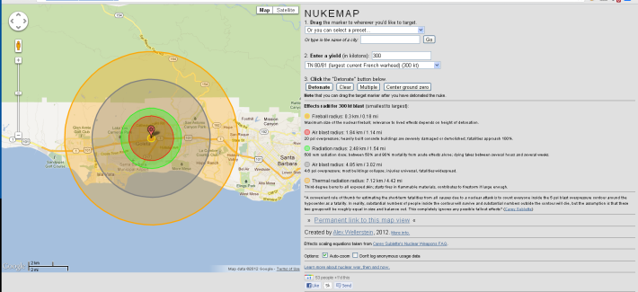
Ever wondered what would happen if the French targeted your house for a nuclear attack?

Or perhaps considered where you would need to be if a stray ‘Dong Feng’ (the largest nuclear missile tested by the Chinese) went off in your local branch of K-Mart?

This super mash-up lets you pinpoint your favorite target on the map, select your preferred choice of radiation delivery and hey presto – see how areas in the immediate vicinity will be affected by the fireball, air blast and thermal radiation.

The map includes a permalink feature so you can send your finished vision of Armageddon to your friends. It sure beats ‘Elf Yourself’.

Try it this weekend – You’ll have a blast!

Nuke Map - Maps.com

Effects of a direct strike on Maps.com HQ: Dont panic - this blog is hosted out of the danger zone.

13
Dec
11

I need a bigger stocking

A perennial favorite by Maps.com editors and staffers (and not just because we update the maps), The World Almanac 2012 has hit the shelves ready to take its place as one of the top gifts for this holiday season.

Think you can get all the information you need from the internet? Think again. Where else will you find curated, researched, accurate information all in one place. It sure as heck won’t be Wikipedia. And as was pointed out in an interview with World Alamanac editor Sarah Janssen on WITF’s Radio Smart Talk on Monday morning, Americans are fascinated by lists. The best this, the top that. And pushing 1000 pages, the World Almanac is chock full of lists.

The editor’s most surprising fact in the Almanac this year? Sales of mobile devices in the U.S. topped 80 million units this year. Not surprising you say? Consider that means that there was approximately one mobile device sold for every 4 persons in the country. Woof. That’s a lot of devices.

If you fear that Santa won’t be able to fit The Almanac into your stocking, Sarah points out that “you can just make that stocking a little bigger this year!”

Buy The Almanac wherever books are sold or at WorldAlmanac.com

07
Dec
11

Future Graduate of the Maps.com University.

One of our super Cartographers here in Goleta sent around this super video of the next cartographic prodigy. She has a great handle on the Political Wall Map of the United States. We haven’t dated the footage, but there is little chance that this is a home movie which Brandi provided, based upon the fact that she is in her mid-twenties. Due to health and safety concerns we have already put up a sign in our editing department prohibiting the ‘Smarty Pants Dance’ every time a edit is made.

27
Oct
11

Maps.com makes its Good Morning America debut!

Maps.com products featured this morning on Good Morning America. The Secret Steals and Deals segment featured ‘Favorite things’ as suggested by News Anchors from the show. After growing up in Los Angeles, and graduating from our local university UCSB, Josh Elliott selected Maps and Globes as some of his favorite things.

It was a great reminder to the viewing audience that as much as we rely on GPS, Bing Maps and Google for our directions, there really is no substitute for something that you can touch and feel, and use your own eyes for zooming in and out!

Thank you so much to Tory Johnson, who spends much of her time helping small businesses and individuals in the workplace, and who pulled it all together for us!

Maps.com Good Morning America

http://cdnapi.kaltura.com/index.php/kwidget/wid/0_4g51ca5k/uiconf_id/5590821

19
Aug
11

art that takes you places

Matthew Cusick’s art has a hidden side. Get close up and you will see that he has created these wonderful collages from recycled maps.

Using topography, street lines, shading and borders he creates meticulously detailed works that make stunning viewing. The subject matter varies, from horses, to waves and freeway interchanges. A graduate of The Cooper Union for the Advancement of Science & Art, Matthew resides in Dallas, TX. His work has shown across the world including numerous exhibition in his birthplace, New York City.

He gave this interview to Alice’s Blog at My Modern Met in March of 2011.

What got you into creating portraits and landscapes with maps?
About nine years ago, frustrated with paint and brushes, I just started experimenting with some maps I had laying around the studio. I found that maps have all the properties of a brushstroke: nuance, density, line, movement, and color. Their palette is deliberate and symbolic, acting as a cognitive mechanism to help us internalize the external. And furthermore, since each map fragment is an index of a specific place and time, I could combine fragments from different maps and construct geographical timelines within my paintings.

Maps provided so much potential, so many layers. I put away my brushes and decided to see where the maps would take me. I think collage is a medium perfectly suited to the complexities of our time. It speaks to a society that is over-saturated with disparate visual information. It attempts to put order to the clutter and to make something permanent from the waste of the temporary. A collage is also a time capsule; it preserves the ephemera of the past. It reconstitutes things that have been discarded. A collage must rely on a kind of alchemy; it must combine ordinary elements into something extraordinary.

How long does one piece take?
It is hard to say exactly. I never keep track of the hours. I’ll work on a piece for two or three weeks and then put it aside and start a new one. To really understand what is going on in one piece I need to be working on another. I’ll usually have at least two or three in rotation. I just finished a sixteen-foot wave commission that I’ve been working on for a year. Normally, a four-by-six foot piece takes about three months to complete. The smaller ones can take three to six weeks. The portraits are the most difficult, no matter what size. Sometimes I scrape off all the maps and start over again, and some subjects I work and re-work for years.

How much paint do you use on top of the maps?
I never paint on the maps. I let the maps be themselves and they establish the palette for me. Sometimes there will be an underpainting that is revealed when I scrape off maps that aren’t working. These areas are never planned though, just happy accidents. I do often paint the sky of a composition a single flat color.

If I need to manipulate the values of the maps in order to achieve richer darks, I use ink, mostly walnut ink that I make myself. This way I am not really adding a new medium to the map, only increasing one that is already there—the ink.

What’s your creative process like? What dictates who or what you’ll create next?
I am always thinking about new creations. Usually my best ideas come to me as I’m working on something else or just keeping busy in the studio. Whenever they come I jot them down in a notebook. Then, when I am ready to start something new I look through these notebooks. There are deadlines, and commissions, and sometimes these can lead to your best work as well, but my creative process is very unpredictable. I typically don’t commit myself to anything but the few pieces that have made it from my notebook to hanging in my studio as works in progress. The next pieces are determined by the outcome of the ones that proceeded them.

How has the internet helped you with your career?
My work has traveled very little outside of the United States. The internet has enabled people from all over the world to see my work. Yet they are still only seeing the digital reproductions. Even so, it is a wonderful thing to know that the work is being seen and admired globally.

Many Rivers

Horse

Geronimo

Related Articles -:

http://www.magicalurbanism.com/archives/3993

http://www.odditycentral.com/pics/the-incredible-map-collages-of-matthew-cusick.html

http://www.indoek.com/archives/4098

http://creativemapping.blogspot.com/2007/05/matthew-cusick-map-art-car-travel.html

06
Jun
11

beware the map police

The crackdown that we suggested would take place on unlicensed mapping in China has begun in earnest. Or Beijing, if you want to be pedantic.Mapworld - China's Google

Possible Punishment for offenders? Linschoten, 1599.

Following the launch of Mapworld by the State Bureau of Surveying and Mapping, the Chinese government said that all providers of online Mapping, including Google, would require a state issued license by July 1st. Reminders of the imminent deadline are now being issued by the bureau’s press office.

Many unauthorized sites and applications which use geolocation are powered with free Google Maps, whereas those approved providers purchase government supplied mapping. According to the bureau this protects the consumer and also prevents sensitive local information from being released.

In all, 46 sites have been ordered to change their mapping provider to get government approval or face as yet unknown punishment. Those contacted include the Chinese social media site Jiepang, who have already applied for a license and sent employees to take part in government ‘training’.

07
Feb
11

“I am Free Today”

The results of the Southern Sudan independence referendum were released in Khartoum today and the results indicated a landslide of 99% in favor of dividing Africa’s largest country.

The result is not without controversy, however, as human rights groups expressed alarm at reports that the Sudanese President Omar al-Bashir be given a temporary reprieve from war crimes charges and that the US State Department indicated it is initiating the process of withdrawing Sudan’s State Sponsor of Terrorism designation.

While the announcement was greeted with jubilation in Southern Sudan, many fear that without the continued pressure on al-Bashir, the relative peace of the referendum will be short lived indeed. In fact, in Khartoum there have been reports in the past week of the government brutally putting an end to student protests and the Sudanese military continuing violent campaigns in Darfur, deepening the concern.

Many questions remain before both countries, not the least of which is the citizenship of the displaced Southerners in the North, oil revenues and much more. The formal declaration of independence will be made on July 9, 2011.

But what does that mean for map makers and those that use maps? One big question is what will be the name of the new country. Officials in the South say that the issue is unresolved, but the name could well be South Sudan.

To complicate the Sudan situation, there is another territory in play: the oil-rich Abyei region, which lies in the center-south of the country, bordering the new South Sudan, has been the site of most of the violence during the referendum and was scheduled to hold its own referendum at the same time as the South Sudan referendum, but disagreements over eligibility and violence sidetracked the vote.

So what do you do if you are about to go to press with a product that has maps that show the current boundaries of Sudan or Africa? We suggest that until there is a definitive referendum on the status of Abyei , the region should be included in Sudan (north). In most cases, the scale of maps that show Sudan will be hard to distinguish the Abyei region, so should pose no confusion to users. Also, if your products are scheduled to go to press before the July 9 independence declaration, the new country should be labeled as South Sudan. However, keep your eye on InCarto and other news sources in case a new name is announced in advance. It’s always better to have the first product with the new name than it is to be the last with the old one.

map of Sudan and South Sudan

The Sudan Split: Sudan and South Sudan (courtesy Maps101)


Sources:

US State Department: Africa: Congratulating Sudan on the Results of the Southern Sudan Referendum

The Guardian

The Sudan Tribune


Enter your email address to subscribe to this blog and receive notifications of new posts by email.

Join 330 other subscribers